Even when alerts exist, response at the barangay level can still be delayed, inconsistent, or undocumented.
LGUs need more than hardware-based warning and one-way communication. They need a unified ecosystem that turns information into action.
Fragmented information sources
PHIVOLCS, PAGASA, water-level systems, and local reports arrive through different channels with no unified view.
Delayed relay to barangays
Critical advisories often take too long to reach barangay-level responders where last-mile action happens.
Weak field coordination
Limited visibility between operations centers and frontline personnel slows decision-making.
Untracked acknowledgments
Field actions are inconsistently logged, leaving command staff without proof of receipt or response.
No mobile tools for frontliners
Barangay-level DRRM actors lack integrated mobile applications to receive, report, and act in real time.
Hazard data without action guidance
Technical bulletins reach responders without being converted into clear, role-based instructions.
From scattered hazard signals to coordinated frontline action.
A layered architecture that ingests authoritative data, applies agentic AI triage, routes to the right people, and closes the loop with field acknowledgment.
Extends — not replaces — the existing Shofar EWS: Public Address, Surveillance, Alarm, Bulk SMS, Weather Station, and IP-PABX integrated into one operational ecosystem.
One platform. Two clients. One shared response.
A mobile app for barangay-level frontliners and a web dashboard for the LGU operations center — both connected to the same data, alerts, and agentic AI layer.
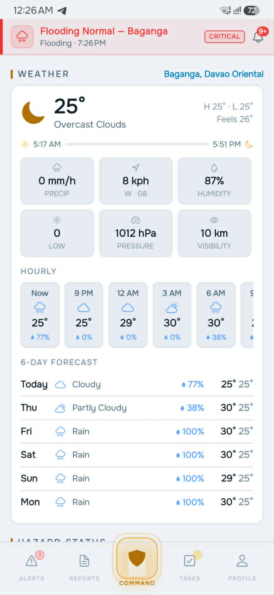
Frontline Mobile App
A role-based mobile app for barangay captains, BHWs, tanods, and field responders. Built for the realities of disaster conditions — including poor connectivity.
What it does- Push notifications by role and area
- Alert acknowledgment — Received, Under Action, Completed, Needs Support
- Incident reporting with text, photos, voice notes, and structured forms
- Hazard SOP / playbook guidance per emergency type
- Contact and coordination directory
- Offline-capable forms that sync when connectivity returns
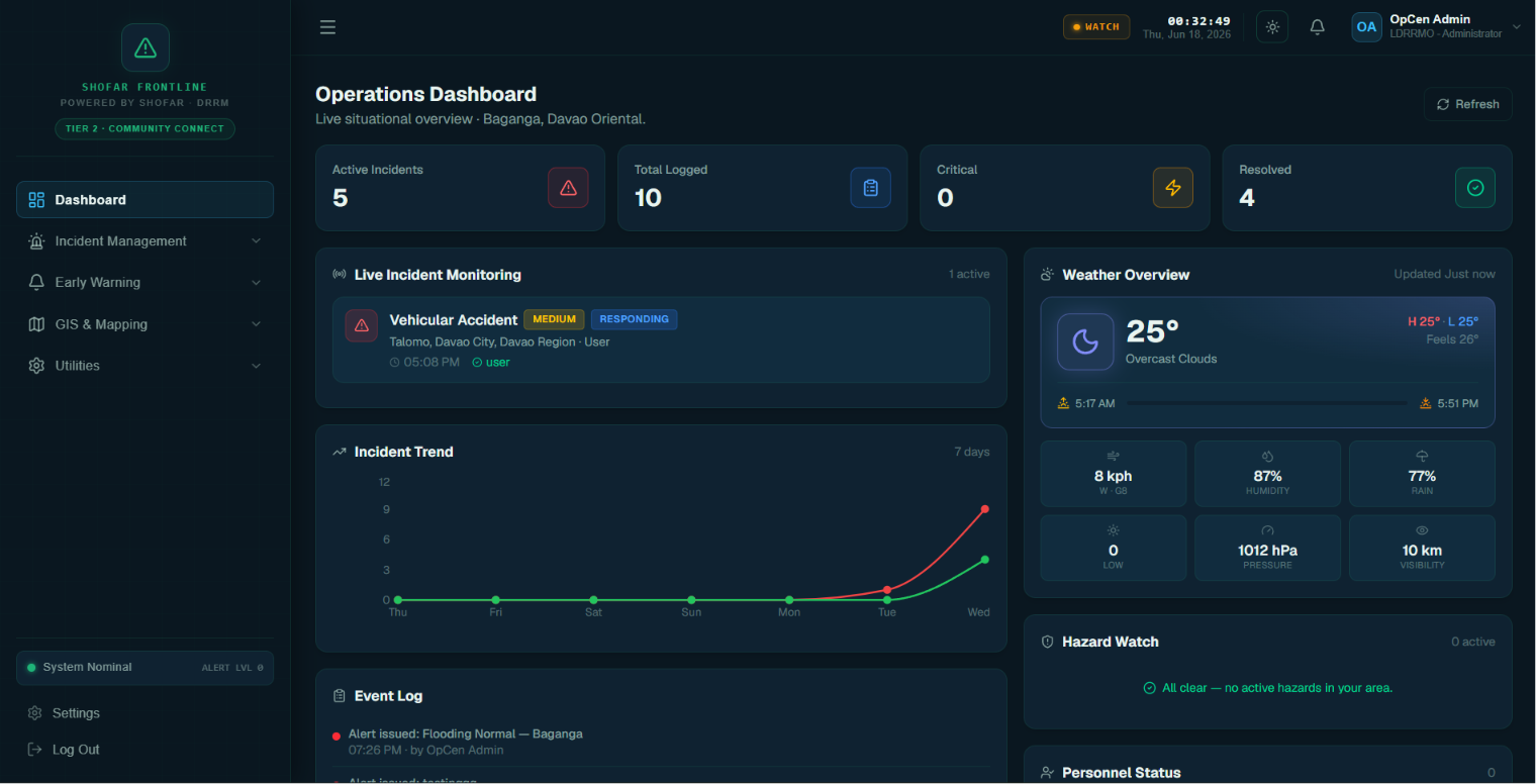
Operations Center Dashboard
A web-based command interface for MDRRMO / PDRRMO and city or municipal command centers. Live visibility into every alert, acknowledgment, and field action.
What it does- Live incident monitoring and hazard watch
- Field acknowledgment tracking across barangays
- Task assignment with location, deadline, and priority
- Personnel and team visibility
- User, role, and access management
- Event log, decision support, and AI situation summaries
Both the mobile app and the web dashboard are powered by the same agentic AI layer — filtering, validating, prioritizing, routing, and summarizing alerts so the right people see the right information at the right time.
Nine integrated capabilities, built for disaster reality.
From hazard feed to offline reporting — every feature is designed for frontline responders, not just command-center analysts.
Hazard & Alert Feed
Categorized stream of disaster-related information — Hydromet, Water-Level, Earthquake Watch, Storm Track, and Local alerts.
Push Notifications
Role-based and area-based notifications for advisories, warnings, evacuation instructions, and live assignments.
Alert Acknowledgment
Quick actions — Received, Under Action, Completed, Needs Support — give command staff real-time response visibility.
Incident Reporting
Field reports through text, photos, videos, voice notes, and structured forms for damage, casualties, and conditions.
Task Assignment & Monitoring
Assign tasks with location, deadline, priority, and responsible user — track status across the entire response.
AI Situation Summary
Readable summaries — what happened, where, who was notified, what's ongoing, and what needs escalation.
SOP / Playbook Guidance
Preloaded action guides for earthquake, flood, typhoon, landslide, storm surge, fire, and health emergencies.
Contact & Coordination Directory
One-tap access to DRRM, ambulance, police, fire, health units, barangay officials, and utility providers.
Offline-Capable Field Forms
Encode reports without connectivity, then sync automatically once the network returns — built for disaster reality.
Built for every actor in the DRRM chain of response.
From barangay captains in the field to LGU operations staff at the command center — each role gets the right interface, alerts, and visibility.
Barangay Captains
Immediate access to relevant alerts, clearer tasking, and improved command visibility at the barangay level.
Barangay Health Workers
Timely health advisories, coordinated response during emergencies, and faster reporting of vulnerable individuals.
DRRM Personnel & Responders
Better field coordination, guided response actions, and improved tracking of assignments and incident updates.
Tanods / Security
Clear operational instructions for local support, patrols, evacuation assistance, and incident response.
LGU DRRM Operations Staff
Faster relay of disaster information, stronger barangay coordination, and complete documentation of actions taken.
Local Chief Executives
Faster situational understanding through summarized alerts, incident dashboards, and monitored response progress.
Accountability, integrity, &
safer locality.
Bring Shofar Frontline to your LGU. We'll guide you through a live walkthrough of the platform, agentic AI agents, and integration with your existing Shofar hardware.
Click the address to copy it — we typically reply within one business day.